


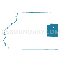
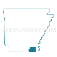
Portland Rural Voting District, Ashley County, Arkansas
About
Outline

Summary
| Unique Area Identifier | 525855 |
| Name | Portland Rural Voting District |
| County | Ashley County |
| State | Arkansas |
| Area (square miles) | 68.10 |
| Land Area (square miles) | 67.39 |
| Water Area (square miles) | 0.71 |
| % of Land Area | 98.96 |
| % of Water Area | 1.04 |
| Latitude of the Internal Point | 33.21049870 |
| Longtitude of the Internal Point | -91.53097440 |
Maps

Graphs
Select a template below for downloading or customizing gragh for Portland Rural Voting District, Ashley County, Arkansas


Neighbors
Neighoring Voting District (by Name) Neighboring Voting District on the Map
- Beech Creek Voting District, Ashley County, AR
- Carlton Rural Voting District, Chicot County, AR
- Mist Voting District, Ashley County, AR
- Montrose Rural Voting District, Ashley County, AR
- Parkdale Rural Voting District, Ashley County, AR
- Planters Rural District 1, Chicot County, AR
- Portland City Voting District, Ashley County, AR
- Snyder Trafalgar Voting District, Ashley County, AR
Top 10 Neighboring County Subdivision (by Population) Neighboring County Subdivision on the Map
- Carlton township, Chicot County, AR (5,086)
- Planters township, Chicot County, AR (3,481)
- Portland township, Ashley County, AR (540)
- Montrose township, Ashley County, AR (367)
- De Bastrop township, Ashley County, AR (319)
- Prairie township, Ashley County, AR (277)
- Banner township, Ashley County, AR (158)
- Beech Creek township, Ashley County, AR (46)
Top 10 Neighboring Place (by Population) Neighboring Place on the Map
Top 10 Neighboring Unified School District (by Population) Neighboring Unified School District on the Map
- Hamburg School District, AR (9,516)
- Lakeside School District, AR (5,398)
- Eudora Public Schools, AR (3,481)
Top 10 Neighboring State Legislative District Lower Chamber (by Population) Neighboring State Legislative District Lower Chamber on the Map
Top 10 Neighboring State Legislative District Upper Chamber (by Population) Neighboring State Legislative District Upper Chamber on the Map
Top 10 Neighboring 111th Congressional District (by Population) Neighboring 111th Congressional District on the Map
Top 10 Neighboring Census Tract (by Population) Neighboring Census Tract on the Map
- Census Tract 801, Chicot County, AR (3,595)
- Census Tract 9601, Ashley County, AR (1,928)
- Census Tract 9604, Ashley County, AR (1,801)